
Planning to hike the Bornholm Coastal Path? This 2026 guide covers the best sections of the 120km Kyststien, including where to find the famous round churches, the best smoked herring, and the top shelters and camping spots.
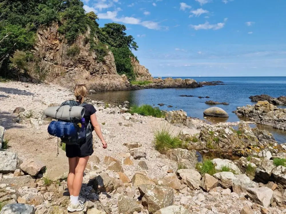
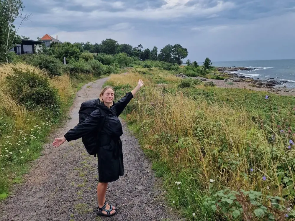
Imagine the sun rising over the ancient Hammershus Castle ruins, casting golden hues on the granite cliffs. Whether you are feeling the soft, white sand of Dueodde Beach between your toes or the exhilarating salty sea spray of the rugged northern coast, hiking the Bornholm Coastal Path is an unforgettable experience.
This comprehensive Bornholm Guide is your passport to exploring every hidden cove, picturesque harbor, and trail that winds through the heart of Denmark’s sunshine island.
Planning your trip? My Bornholm Favorites:
🚢 Ferry: Book your ferry tickets via Bornholmslinjen here – The easiest way to reach the island from Ystad or Køge.
🚌 Bus: Find budget tickets to Bornholm with FlixBus – The most affordable way to get from Copenhagen to Rønne.
🚗 Car Rental: Compare car rental deals on DiscoverCars or find a relocation deal for $1 on Imoova – Essential if you want to explore the island’s hidden gems.
🏨 Hotels: See the best Bornholm stays on Booking – My top picks are Hotel Gudhjem for charm or Holiday Home Frederikke for history and authenticity.
🎟️ Tours & Activities: Book guided Bornholm tours and activities on Viator – Don’t miss out on the legendary Hammershus Castle Ruins!
✈️ Flights: Check Danish Air Transport for domestic hops — Copenhagen to Rønne is a the fastest and easiest option to reach the island.
🛡️ Insurance: Don’t travel without cover. I use VisitorsCoverage – It’s affordable, easy to set up, and essential for unpredictable jungle adventures.
📱 Connectivity: Stay connected with a Saily eSIM – Avoid roaming charges and get instant data for your trip to Bornholm.

A note from Sara:
There are affiliate links in this post, and I may earn a small commission if you choose to make a purchase – at no extra cost to you. It’s a great way to support my work if you found this guide helpful – thank you so much!
Bornholm Coastal Path Quick Overview
Trail Overview
- Location: Bornholm Island, Denmark
- Starting Point: Rønne
- Distance: 120 kilometers
- Duration: 5–7 days for the full trail
- Difficulty: Moderate, with varying terrain
- Elevation Gain: Approximately 1,500 meters over the entire path
- Best Time to Hike: Late spring to early autumn (May to September)

Getting to the Bornholm Coastal Path
By Air
If you’re the type who likes to take to the skies, Bornholm’s got you covered. The easiest way to reach this Baltic gem is via Bornholm Airport, just a stone’s throw from Rønne. With regular flights from Copenhagen, you can hop on a plane and be soaking in those island vibes in under an hour.
By Ferry
For those who prefer a more nautical approach, set your sights on the Bornholmslinjen Ferry. There’s something undeniably romantic about arriving by sea, watching the island grow on the horizon. Ferries run from Køge and Ystad, and Sassnitz, connecting Bornholm to mainland Denmark, Sweden, and Germany. The crossing from Ystad, Sweden, is the most popular and offers a quick, scenic journey.
By Train or Bus
You can go with a DSB Train from Copenhagen to Ystad. Once you reach Ystad, the ferry terminal is just a short walk from the train station, making for a seamless transition from rails to sails.
You can also grab a Flixbus from Copenhagen to Rønne (Ferry included) for approx. 25 USD or use another bus service called Kombardo Expressen.
By Car
For ultimate freedom rent a car and drive to Bornholm. It’s pretty simple – from Copenhagen, head to Ystad and catch the ferry. Just remember to book your ferry ticket in advance, summer can get busy! Don’t forget to check out Imoova for relocation deals—you might be able to snag a car for $1 a day!

Choose Your Route: Clockwise or Anti-Clockwise?
Since you’ll most likely arrive by ferry or plane in Rønne, that’s your starting point. The big question is: do you head North toward the cliffs or South toward the sand? Here’s the breakdown:
Going Clockwise (Heading North first)
This is the most popular choice, and for a good reason. You dive straight into the dramatic stuff.
- The Pros: You hit the “highlights” like Hammershus and the massive cliffs at Hammerknuden within the first couple of days while your legs are still fresh. It feels like a grand opening to your trip. Plus, the trail starts with a bit of a challenge, which I personally like.
- The Cons: The southern part of the island (the end of your trip) is much flatter and more “beach-heavy.” Some people find it a bit of an anticlimax to go from epic cliffs to flat bike paths and sandy dunes at the very end. Also, depending on the season, you might face a bit more headwind heading North.
Going Anti-Clockwise (Heading South first)
If you want a “slow burn” and a more relaxed start, go South toward Dueodde first.
- The Pros: The terrain South of Rønne is way easier on the knees. It’s a great way to “walk yourself in” before the real climbing starts. You’ll often have the wind at your back, which is a massive plus on a coastal hike. Ending your trip with the wild, rugged cliffs of the North feels like a proper finale.
- The Cons: You’re walking on a lot of flat stretches and sandy beaches in the beginning. If you’re here for the “mountain-vibe,” you might get a bit impatient during the first few days before the scenery really shifts.
A Few Practical Tips
- Be Flexible: Don’t over-plan. Sometimes you’ll find a spot where you just want to hang out for an extra hour (or a day). Build in some buffer time.
- Food & Supplies: Even though Bornholm is small, some stretches are surprisingly quiet. Most towns have a Coop or a Netto, but always carry enough water and a few snacks. You don’t want to run out of steam halfway between two fishing villages.
- Use the Apps: Download the Shelter app if you’re camping, and keep an eye on Google Maps. The trail is well-marked with orange signs, but it’s always nice to know exactly how far it is to the next ice cream shop.
7-Day Itinerary on the Bornholm Coastal Path
So, in the following, I’ll break down this scenic journey into manageable sections, heading in a clockwise direction.
Section 1: Rønne to Hasle
Distance and Estimated Time: 20 km – 5 to 6 hours
Terrain and Difficulty Level: Mostly flat with a few gentle inclines. Easy to moderate.
Stay: There’s a nice, free shelter in Hasle Lystskov, see map for directions.
Points of Interest and Highlights:
- Rønne: Start your journey in the island’s largest town. Explore its charming streets, grab some coffee, and visit the Bornholm Museum if you have time.
- Klympen Beach: A peaceful spot to soak in the sea views and breathe in that fresh Baltic air.
- Hasle: The quaint village with its picturesque harbor, traditional wooden houses, and the Hasle Havn, where you can watch local fishermen at work.

Section 2: Hasle to Hammerknuden
Distance and Estimated Time: 20 km – 5 to 6 hours
Terrain and Difficulty Level: Varied terrain with some rocky paths and moderate hills. Moderate to challenging.
Stay: Immerse yourself in nature by staying at the free shelter near Opal and Hammer Lake, set in some of the most gorgeous surroundings. See the map for directions.
Points of Interest and Highlights:
- Hammershus: Explore the ruins of Northern Europe’s largest castle. The panoramic views from the castle’s heights are absolutely breathtaking.
- Hammerknuden: The rugged rock formations here are a highlight. Keep your camera ready for some spectacular shots.
- Opal- and Hammer Lake: Two stunning, neighboring lakes in the Hammer-area. The path here offers lush greenery and calming waters.
- Sandvig: If you don’t want to stay in a shelter, the nearby village of Sandvig has a few options for lodging and dining. It’s a great spot to unwind after a long day of hiking.
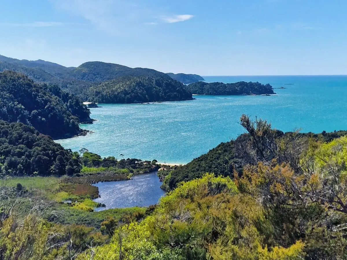
Section 3: Hammerknuden to Gudhjem (almost)
There are no free shelters near Gudhjem, so this section will guide you to the nearest shelter outside the town, called Røstad Kystshelter (coast shelter).
Distance and Estimated Time: 20 km – 5 to 6 hours
Terrain and Difficulty Level: Varied terrain with a mix of forest paths, rocky stretches, and coastal trails. Moderate to challenging.
Stay: Stay at one of the two free small cozy coast shelters at Røstad, near Gudhjem. Røstad Kystshelter is a popular spot, so if you’re arriving late, be prepared for the possibility of sharing the shelter with other hikers or pitching your tent.
Points of Interest and Highlights:
- Hammerknuden: Soak in as much of the natural beauty of the Hammer Area as you need before you leave. In my opinion, this is the most spectacular nature you’ll encounter on your hike, so make sure not to rush through it.
- Fish Buffet: In Allinge, take the time to explore its quaint shops and perhaps indulge in a hearty meal at one of its local restaurants, which are especially known for their excellent fish buffets.
- Helligdomsklipperne: Be sure to explore the Helligdomsklipperne sea cliffs before settling at the shelter, famous for their dramatic rock formations and stunning coastal views.
Section 4: Gudhjem to Svaneke
Distance and Estimated Time: 22 km – 5 to 6 hours
Terrain and Difficulty Level: Varied terrain including coastal paths, rocky stretches, and gentle hills. Moderate.
Stay: There are no free shelters or tent sites in Svaneke. The closest option is a free tent site located 6.5 kilometers away from Svaneke (The site is private property but to my knowledge, it’s free, but you can only stay between 6pm and 10am). Given the distance, why not stay in the beautiful town of Svaneke overnight?
Points of Interest and Highlights:
- Gudhjem: Spend your morning in this charming town known for its quaint streets and traditional smokehouses. If you haven’t already, try the local specialty, smoked herring, before setting off.
- Østerlars Rundkirke: On your way, you could make a slight detour to visit this historic round church, renowned for its unique architecture and rich history.
- Svaneke: Your destination, Svaneke, is a picturesque village with colorful houses and a vibrant atmosphere. The town has several excellent options for lodging and dining, so it’s a great place to end the day and enjoy the local cuisine.

Section 5: Svaneke to Snogebæk
Distance and Estimated Time: 18 km – 4 to 5 hours
Terrain and Difficulty Level: Moderate with a mix of coastal trails and forest paths. Some sections may be rocky.
Stay: There are two small coastal shelters by the harbor in Snogebæk and one larger “madpakkehus” that accommodates 4-5 people. It’s a popular spot, and the shelters operate on a first-come, first-served basis. If you don’t secure a spot, you can always pitch your tent nearby.
Points of Interest and Highlights:
- Nexø: As you continue on the Bornholm Coastal Path, make sure to stop in Nexø, the island’s second-largest town. It’s known for its maritime history, bustling harbor, and local eateries. A great spot to explore before heading to your next destination.
- Snogebæk: Your destination, Snogebæk, is a quaint village with a lovely harbor and a few cozy spots to stay the night. It’s a great place to enjoy a meal by the sea and explore local shops. Nettis is a great place for homemade ice cream, eat at Levertranfabrikken for Italian gourmet pizzas, and visit Søren’s Værtshus for a beer and atmosphere.

Section 6: Snogebæk to Boderne Harbor
Distance and Estimated Time: 24 km – 5 to 6 hours
Terrain and Difficulty Level: Mostly flat, with some coastal and forested paths. Moderate.
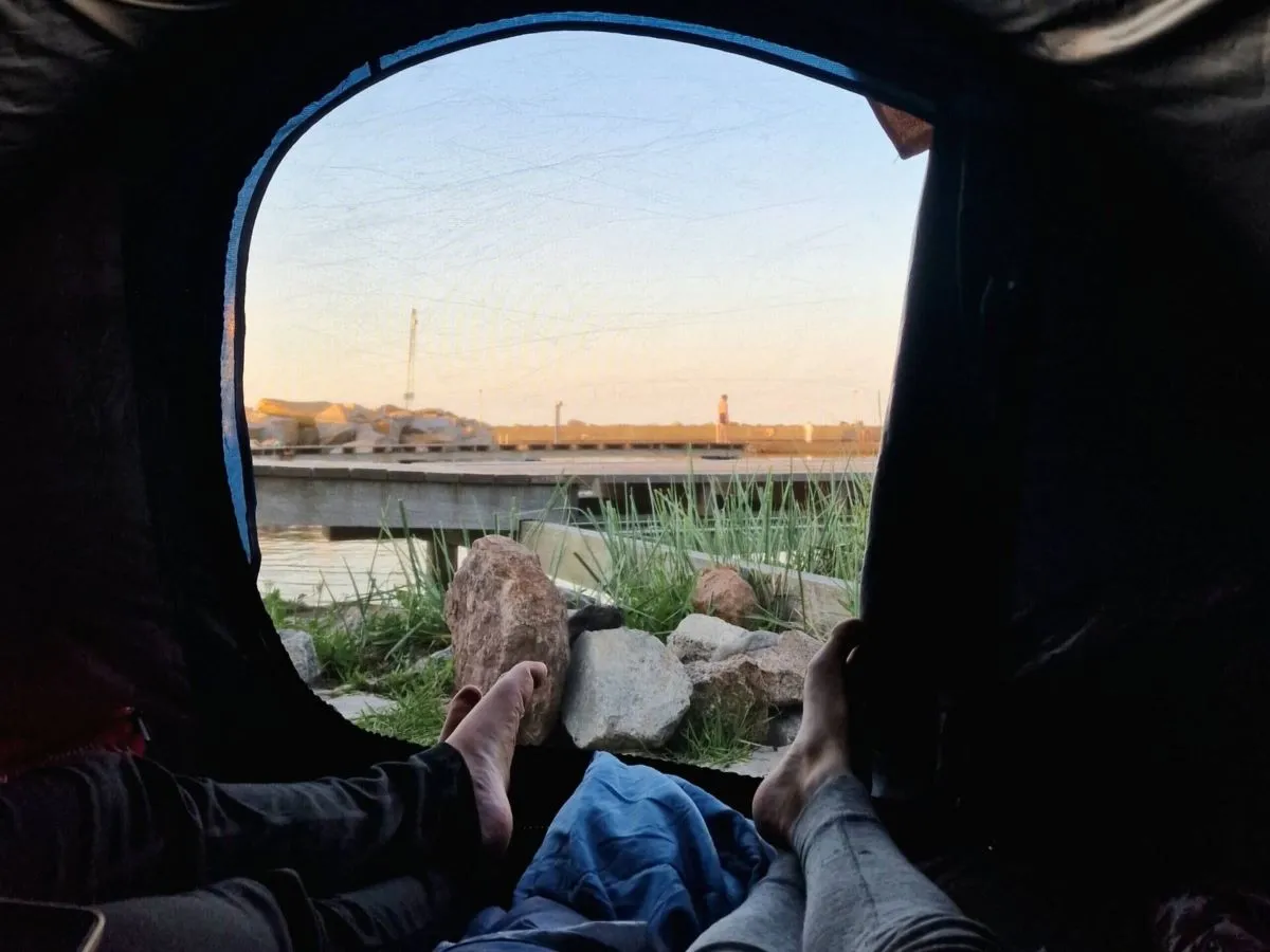
Stay: You’ll find two free coastal shelters at the Boderne harbor, each with space for 3 adults.
Points of Interest and Highlights:
- Dueodde Beach: As you head west, make a stop at Dueodde Beach. Known for its fine white sand and clear waters, it’s a perfect place for a refreshing break or a leisurely stroll along the shore.
- Dueodde Lighthouse: Near Dueodde Beach, this historic lighthouse offers stunning panoramic views of the Baltic Sea and the surrounding landscape. A great spot for photos and a quick rest.
- Boderne Harbor: Your destination, Boderne Harbor, is a picturesque harbor area where you can relax and unwind. The small harbor is a peaceful spot to conclude your hike for the day and soak in the tranquil maritime atmosphere.
Section 7: Boderne Harbor to Rønne
Distance and Estimated Time: 20 km – 5 to 6 hours
Terrain and Difficulty Level: Mostly flat with a mix of coastal and forested paths. Moderate.
Points of Interest and Highlights:
- Arnager: On your way to Rønne, stop by the small fishing village of Arnager. It’s known for its charming wooden jetty, the longest in Denmark, extending into the Baltic Sea.
- Nylars Rundkirke: A slight detour inland will take you to Nylars Rundkirke, one of Bornholm’s distinctive round churches, rich with history and unique architecture.
- Rønne: Your final destination, Rønne, is Bornholm’s largest town. Explore its historic sites, such as the Rønne Town Hall and the Bornholm Museum. Enjoy a meal at one of the local restaurants or cafés and celebrate the completion of your hike.
Where to Stay on the Bornholm Coastal Path
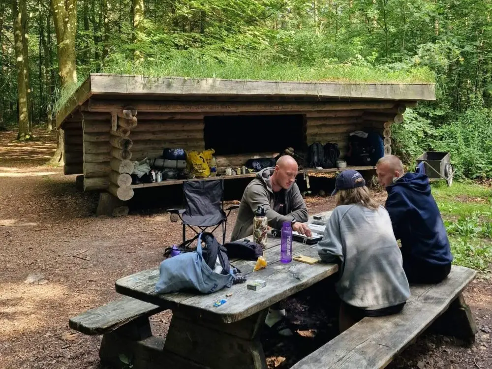
Shelters and Campsites
If you’re into the whole “back to basics” thing, Bornholm is actually pretty great. There are free shelters and tent sites scattered all along the coast. It’s definitely the most authentic way to experience the island—nothing beats waking up to the sound of the ocean and the smell of fresh sea air.
The Good Stuff:
- It’s Free: Your budget will love you, and you’ll have more money to spend on ice cream and smoked herring in the towns.
- The Locations: A lot of these spots are in places where you’d otherwise pay a fortune for a hotel view.
- Zero Stress: No check-in times or reception desks. You just show up and set up camp.
The Not-So-Good Stuff:
- Very Basic: Don’t expect much. Most spots just have a wooden shelter, a place for your tent, and a fire pit. If you’re lucky, there’s a compost toilet nearby, but that’s about it.
- No Reservations: It’s first-come, first-served. In the middle of summer, it’s a bit of a gamble. Pro tip: Always bring a lightweight tent. If the shelter is full, you’re usually allowed to pitch your tent right next to it.
How to find them:
- Get the App: Download the Shelter App. It’s a lifesaver. It shows you exactly where the spots are, what kind of facilities they have, and if they’re actually free or require a small fee.
- Watch the Signs: Keep an eye out for the small blue signs with a tent or shelter icon along the trail.
- Ask around: If your phone dies, just ask a local. Most people are super helpful—even if the Bornholm accent can be a bit of a struggle to understand at first!
Cozy Bed & Breakfasts
If you’re not the camping type—or if you just need a break from the tent—Bornholm has some amazing B&Bs. It’s the perfect middle ground between a cold shelter and a fancy hotel. You get a hot shower, a real bed, and a breakfast that’ll actually keep you going for the next 20 kilometers.
My Top Picks:
Booking.com has plenty of options, but it can be a bit of a jungle to navigate. You can check out the full selection here, but here are a few spots that are actually worth your time:
Bølshavnvej 5 B&B (Svaneke) If you want that authentic, “old farmhouse” vibe, this is it. It’s run by Peter, who’s a legend of a host. You’ll get a solid homemade breakfast, and there are even some friendly animals hanging around.
Badepensionat Sandloppen (Sandvig) This place is located in Sandvig, which is one of my favorite towns on the island. You’re only 400 meters from the beach, which is a massive plus if you want a quick dip before starting your hike.
Myregaard B&B and Apartments (Snogebæk) Located in the cozy fishing village of Snogebæk, this place feels like a little oasis. They have private entrances and even a small kitchen, which is great if you’re tired of eating out and just want to prep your own trail snacks.
Guesthouses & Inns
If you want something that’s a step up from a B&B but still has that local “inn” vibe, guesthouses are your best bet. They’re usually located right in the heart of the coastal towns, making it easy to grab a beer or a pizza after you’ve dropped your bags.
My Top Picks:
Nexø Hostel: One of the few hostels on the island, so it’s a perfect choice if you want to experience the island on a budget and meet other like-minded travellers.
Pension Holmegaard (Sandvig): This place is right by the water and even has live music some nights. It’s got a great garden where you can just crash after a long day.
Hotel Gudhjem: Right in the middle of everything. It’s a classic spot, very welcoming, and they serve a solid breakfast. Just be aware that Gudhjem gets busy in the summer.
Hotel Skovly (Near Rønne): If you want peace and quiet, this is it. It’s tucked away in a forest, so you’re surrounded by trees instead of tourists.
Boutique Hotels (The “Treat Yourself” Option)
Let’s be real: sometimes, after days of hiking through wind and rain, you just want a bit of luxury. These spots are pricey, but if you’ve got the budget for it, they are incredible.
If You’re Feeling Fancy:
- JANTZENs Hotel (Gudhjem): Super stylish and right in the heart of town. It feels very personal and “boutique” in all the right ways.
- Strandhotel Balka Søbad: Located right on one of the island’s best beaches, this place is all about that relaxed seaside vibe. It even has a pool, which is a massive win if your legs need a break from the saltwater and rocks.
- Hotel Blomme’s Place (Near Dueodde): Close to the beach and has a really cool, modern vibe. The garden and terrace are perfect for a glass of wine after a day on the trail.
Packing List: What You Actually Need
Bornholm isn’t the Himalayas, but the weather can change in a heartbeat. The goal is to keep your pack light (aim for under 12kg if you’re camping) and your feet happy.
The Big Three (Invest here)
- The Backpack: You’ll want a 40-60 liter pack with a solid hip belt. Your shoulders will thank you. [Check out my favorite pack here].
- The Tent/Shelter Gear: A lightweight tent (under 2kg is ideal) or a warm sleeping bag (comfort rating around 5-10°C). Don’t forget a sleeping pad—granite is hard to sleep on!
- The Shoes: Don’t bring brand new boots. Use something you’ve already broken in. Trail runners or lightweight hiking boots work best for the Bornholm terrain.
Clothing (The Layering Rule)
- Base Layer: Moisture-wicking T-shirts (Avoid cotton! It stays wet and makes you cold).
- Mid Layer: A fleece or a lightweight down jacket for those chilly evenings by the campfire.
- Outer Layer: A proper rain jacket and windproof pants. Even if the forecast says sun, the Baltic Sea wind is real.
- Socks: Two pairs of high-quality wool socks (like Merino). One on your feet, one drying on your pack. [My go-to socks for avoiding blisters].
- Swimsuit: Because you will want to jump in the ocean at Dueodde or Sandvig.
Kitchen & Food
- Stove & Fuel: A small Jetboil or Trangia is perfect. You can buy gas canisters in Rønne when you arrive.
- Water: At least 2 liters of capacity. You can refill at harbors, churches, and campsites along the way.
- Spork & Cup: Keep it simple. One pot, one spork, one mug.
The “LifeSavers” (Small but Important)
- The Shelter App: Your digital bible for finding a place to sleep.
- Powerbank: Essential for keeping your phone (and camera) alive for those coastal photos. [This one is rugged and fast].
- Blister Kit: Compeed is your best friend. Don’t wait until it hurts—apply it as soon as you feel a “hot spot.”
- Microfiber Towel: Dries in minutes and takes up zero space.
- Sunscreen: The reflection from the water makes the sun much stronger than you think.

FAQ: Visting Bornholm
What’s the deal with Bornholm? Why should I go there?
Bornholm is Denmark’s secret treasure — a small island in the Baltic Sea with a big personality. Imagine dramatic cliffs, idyllic beaches, charming villages, and a local food scene that’s both traditional and innovative. It’s like someone took a slice of Scandinavia and sprinkled a little magic on it.
When’s the best time to visit Bornholm?
For optimal adventure and sun-soaked escapades, aim for late spring through early fall (May-September). Summer (June to August) is prime time with warmer weather and lively local festivals. If you’re a fan of winter’s serene landscapes and fewer crowds, the off-season has its own charm.
How do I get to Bornholm?
You’ve got options! Fly into Bornholm’s airport (Rønne) from Copenhagen or Malmö, or take a ferry from Sweden or Denmark. If you’re up for a road trip, drive to Ystad, Sweden, and hop on the ferry. The journey itself is a prelude to the adventure.
How long does it take to hike the entire Bornholm Coastal Path?
If you’re a seasoned hiker, you can complete the loop in about 5 to 7 days. It’s flexible though; you can tackle it in sections depending on your pace and interests. There are plenty of spots to stop and soak in the scenery.
Are there places to stay along the Bornholm Coastal Path?
Absolutely. There are cozy guesthouses, charming B&Bs, and free campsites and shelters scattered along the route. Make sure to book in advance during peak season. Shelters can’t be booked; they operate on a first-come, first-served basis.
Are there any must-see spots on the Bornholm Coastal Path?
Yes! Don’t miss the dramatic cliffs of Hammershus, the picturesque village of Gudhjem, and the stunning sandstone formations at Dueodde Beach. Each section of the path has its own unique charm, so keep your camera ready.
Further Resources
If this guide didn’t cover all your questions, I made a list for you with valuable resources to help you make the most of your adventure:
Maps
- Bornholm Tourist Map: Available at local tourist offices and online, this map provides an overview of the island, highlighting key landmarks and trails.
- Komoot and AllTrails: These apps offer detailed, user-generated maps and route suggestions for hiking the Bornholm Coastal Path.
Websites
- Visit Bornholm: www.visitbornholm.com – The official tourism website for Bornholm, providing information on attractions, accommodations, and events.
- Bornholm.info: www.bornholm.info – Another great resource for visitors, offering practical advice, maps, and travel tips.
Local Tourist Offices
- Bornholm Visitor Center: Located in Rønne, this center provides free maps, brochures, and personalized advice to help you plan your hike.
- Local Tourist Information Centers: Found in major towns like Nexø, Svaneke, and Allinge, these centers are great for picking up last-minute supplies and getting local tips.
Apps
- Maps.Me: A personal favorite of mine – an offline map with detailed hiking routes, including the Bornholm Coastal Path.
- Shelter App: Find campsites, shelters, and other essential amenities along the trail.
- Windy App: Get reliable weather forecasts to help plan your hiking days.
Social Media and Forums
- Reddit: r/hiking: Engage with the hiking community for advice, trip reports, and gear recommendations.
- Facebook Groups: Search for groups dedicated to hiking in Denmark or Bornholm specifically, where you can ask questions and share experiences.
Gear Rental and Outdoor Shops
- Outdoor Bornholm: Based in Rønne, this shop rents and sells hiking gear, including tents, backpacks, and cooking equipment.
- Bornholms Outdoor: Located in Nexø, offering a wide range of outdoor equipment and expert advice.
What’s your favorite spot on Bornholm? Drop a comment below and let me know how your adventures went! If you’re looking for more island inspiration, don’t miss my guides to Mallorca for a completely different kind of island scenery.
Leave a Reply